5 weeks at sea!

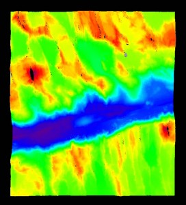
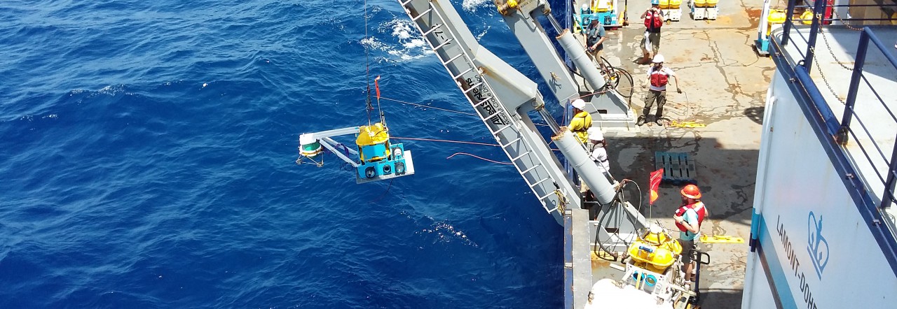
After an intense 5 weeks at sea, picking up 78 instruments and carrying out 3D surveys, we can finally see Tenerife from our ship. Few more hours and we will be back on land.

Thank you to everyone who followed our blog. There will be more updates in the future when we start processing all of our data.

Hope you all enjoyed our little April fools story bout a pirate ship and a gold doubloon!

Signing off from RRS Discovery.


Top (left to right): Mike Kendall, Kate Rychert, Wayne Crawford, Saikiran Tharimena

Middle (l to r): Chris Amerding, Ted Koczynski, Michaela Wenner, Jake Perez, Martin Rapa, Oceane Foix, Simon Bensacon, Daniel Bassett

Bottom (l to r): Sean McPeak, Carlos Becerril, Owain Jones, Matthew Agius, Peter Liljegren

We found a pirate ship, so exciting!!!

Disclaimer: The contents of this article are not true. The authors have written this article as an “April Fools” story and was published on 1st April. If you use this story, please link this article and also include this disclaimer. The authors claim no responsibility for any articles that have been published elsewhere, in print or online, as a result of this story.

When we picked up our last station, we stumbled across what appears to be a shipwreck lying at the bottom of the Atlantic Ocean. We noticed a strange magnetic anomaly, but we weren’t sure what to make of it. Then when we recovered the last of our OBMT instruments off the seafloor we found a gold doubloon wedged into the bottom of the frame. We immediately altered course and began a 3-D bathymetric and magnetometer survey.

We found a peculiar object in the bathymetric data and after closer inspection and processing, a 3-masted sailing vessel emerged from the seafloor! The ship appears to be a traditional wooden vessel. The magnetic readings may indicate the ship is laden with huge numbers of gold doubloons or other precious cargo and cannons.

A pirate ship lodged between the tectonic plates. The colors indicate shallower (red) and deeper (blue) depths. Inset: A gold doubloon that was found wedged into the bottom of the OBMT frame. Ship silhouette copyright: yyang / 123RF Stock Photo

Both exciting and grim, this discovery helps to explain the fate of many a seafarer lost to the locker of Captain Davy Jones.

The shipwreck is located about 2000 metres beneath the sea in a very remote area of the Atlantic Ocean. The ship was found at a special location where the tectonic plates are created, the Mid-Atlantic Ridge. The extreme topography and frequent volcanic eruptions could cause a serious hazard for ships, particularly those that are cargo laden such as pirate ships.

We were advised to keep the exact location secret until authorities have investigated further. We were warned that pirates operate in these waters, but thankfully this ship poses no threat to our safety or our scientific mission.

3D Survey Again

We are now heading north to pick up our last station. But before, we decided to survey another fracture zone along the mid-Atlantic ridge, a region of high seismic activity. There have been hundreds of earthquakes last year including a major 7.1 magnitude earthquake on 29th August 2016. This survey should help us identify surface tectonic features. Some parts of the fracture zone are as deep as 7000 meters, flanked by mountains and ridges as high as 3000 – 4000. The strength and grandiosity of the crustal deformation in this fracture zone is unprecedented, as the African and South American plates are tearing apart and sliding past each other.

Rain won’t stop us now

Despite the few occasional showers that we came across whilst sailing, luckily, the rain always stopped whenever we needed to be on deck. But not this time. We came across torrential rain and there was no sign of it stopping. We put on a brave face, got our rain gear out, and headed to the deck to recover the instruments. Now we can call ourselves true sailors, ready to encounter all kinds of weather, or perhaps not just yet.

Mission Impossible

Following the successful completion of the bathymetric survey we moved on to our next station I04D. Everything proceeded as planned, so we thought! We first released the ocean bottom magnetometer and then conducted a survey to precisely locate the ocean bottom seismometer (OBS) on the ocean floor. At the end of the survey, we sent a burn command that triggers the OBS to release its anchors and rise to the surface. After waiting for the burn sequence to complete, which takes about 15 minutes, we communicated with the OBS to check if it is rising. But unlike all the previous stations, this OBS turned out to be a bit stubborn. We sent a few more burn commands, hoping that it would rise eventually. An instrument stuck on the ocean floor was a likely scenario that we were all prepared for. There are many possible reasons for an instrument to get stuck on the ocean floor – it landed in a wrong position or perhaps it sank into the soft sediments, or the release mechanism malfunctioned. It would be heart breaking to abandon this instrument behind especially because it was still active and communicating.

Captain Antonio Gatti came up with a bold plan. We were to pay out a cable a few hundred meters around the instrument and then slowly start to pull the cable till it nudges the instrument. We had to winch out 4991 meters of cable to reach the bottom of the ocean that took us about 2 hours. We then slowly moved, paying out a total of 5600 meters of cable around the instrument which took us another 2 hours. We then started sailing away from the instrument pulling the cable slowly whilst constantly communicating with the instrument. The ordeal that started at 18:00 finally ended at 23:20 when the instrument confirmed that it was rising! The entire science party was on deck looking for a flashing beacon in the dark when the instrument finally made it to the surface at 00:50 hours. It was a big moment of satisfaction for all of us – mission accomplished!!

3D Bathymetric Survey

We are now entering another phase of our expedition – high resolution imaging of the mid-Atlantic ridge, the place where tectonic plates are born! This is so exciting because we are imaging the ocean floor in a never seen before detail. The images come in near-real time as we sail north – south across the ridge.  The lab is always buzzing with people day and night who stop by simply to look and wander at the amazing structure of the oceanfloor. It is like having a closer look at an alien planet. The ocean is about 5000 meters deep, however, near the ridge it abruptly reduces to about 2000 meters. Some of the underwater mountains are as high as 3000 meters and the steepest walls are about 1800 – 2000 meters high!

The technology that enables us to image these features at a high resolution is based on the simple principle of echoes. An instrument called a multibeam echosounder, that is positioned at the bottom of the ship, emits a sound signal. This signal travels through the water, bouncing off objects and features on the seafloor and are recorded by the instrument. The time that a single beam of sound takes to travel from the ship to the bottom of the ocean and back is recorded. In a previous post we talked about measuring the sound velocity using an instrument called Sound Velocity Profiler. We use this sound velocity information convert the travel time of sound to depths. The longer an echo takes to arrive back, the deeper is the ocean! Using state-of-the-art tools, we process and visualize the oceanfloor in 3D. Here are some magnificient and breath-taking images of the mid-Atlantic ridge.

Follow our navigation live!

We are now sailing west, to the middle of the Atlantic Ocean to survey the Chain Fracture Zone. More on this in the next post. You can see our track live online on this website: http://mars.noc.ac.uk/missions/dy072. DY072 is the operation number for the current PILAB operations on the RRS Discovery. From the website you can see how much we have sailed so far and also read more about the expedition itself.

Another interesting read is the detailed blog of seismologist Prof. Mike Kendall from the University of Bristol. He is a great writer and also an amazing photographer, capturing great moments of people at work, of the ship and the beautiful sunrise and sunsets. Have a look at it yourself: http://jmkendall.blogs.ilrt.org

Third leg of our cruise

We have now recovered nearly 90% of our ocean-bottom instruments, a total of 68 out of 78 instruments! The last few days where the most intense, recovering about 8 instruments a day. These instruments were deployed at the mid – Atlantic ridge at about 50 – 100 km apart. The reason for this short distance between the stations is for us to be able to image the deep structure beneath the ridge at a high resolution. A little duck, brought on board the ship by Prof. Mike Kendall from the University of Bristol, helped us stay on track. The duck is a fieldtrip mascot for the geosciences department at the University of Bristol.

Life on board is more-or-less ‘normal’ albeit the ship being on high alert for pirates the last few days as we were few hundred kilometres from the African coast. The ship was on “lock down” for a couple of days – which meant no one could stay outside on deck unless an instrument was being picked up, all windows and portholes shut, and all external lights, except the navigation lights, were turned off. As we sail away from the African coast, preparations are underway for 4 days of surveying a section of the mid-Atlantic Ridge called the Chain Fracture Zone, which means research techs have a few days off!

A lost soul wandering to the bar!

The Royal Research Ship Discovery

It is indeed an honour to be on board the Royal Research Ship Discovery.

Few ships, if any, hold a name that has a long rich history in Earth science exploration. The history of the RRS Discovery stretches over 2 centuries. In total, 4 ships, including the current one, served the scientific community under this royal name.

While walking through the corridors on board this ship you come across various photos and memorabilia from the previous ships and the numerous expeditions she had been an integral part of. In these pictures, you can see how the ships have changed over time. The first ship was a wooden whaling ship that served as HMS Discovery in the Royal Navy in 1874 for the British Arctic expedition to the North Pole. The first ship to bear the RRS title was the last traditional wooden three-masted ship to be built in Britain, designed for Antarctic research and launched in 1901. It’s first mission was the British National Antarctic Expedition, famously captained by Robert Falcon Scott and Ernest Shackleton, which set sail on 6 August 1901 from the Isle of Wight and sighted the Antarctic coastline on 8 January 1902.

The current ship is the 4th Discovery to bear the RRS title and is one of the world’s most recent and technically advanced scientific research ship, commissioned by HRH The Princess Royal in 2013 in Southampton. There are more Royal Research Ships at present, however, only one holds the legacy of numerous discoveries – the RRS Discovery!

An interesting fact – NASA named one of its space shuttles, Discovery, to honour the legacy of this great ship!

Deep sea temperature and sound velocity

We would like to highlight another vital measurement that we take at each site, the sound velocity and temperature with depth profile. We use a special device that measures pressure, temperature and sound velocity as it is lowered down by a winch. We can literally reach the bottom of the ocean with a pretty long winch cable which is about 6.9 km long! The graph below shows the sound velocity and the temperature with depth down to 2000 metres. It is interesting to see how the temperature decreases rapidly to about 5 degrees Celsius at 700 metres depth and then decreases gradually to about 3 degrees Celsius at 2 km depth. The sound velocity also decreases rapidly from about 1540 metres per second at the surface down to about 1480 m/s at about 700 metres depth, however it starts to increase gradually with depth below 700 metres depth. The main reason for its increase is due to increase in pressure and density. The sound velocity profile is an important measure when imaging the topography of the ocean floor…. more on that in an upcoming post.

A Sound Velocity Profiler (SVP) is ready to get winched to 2000 metres.